
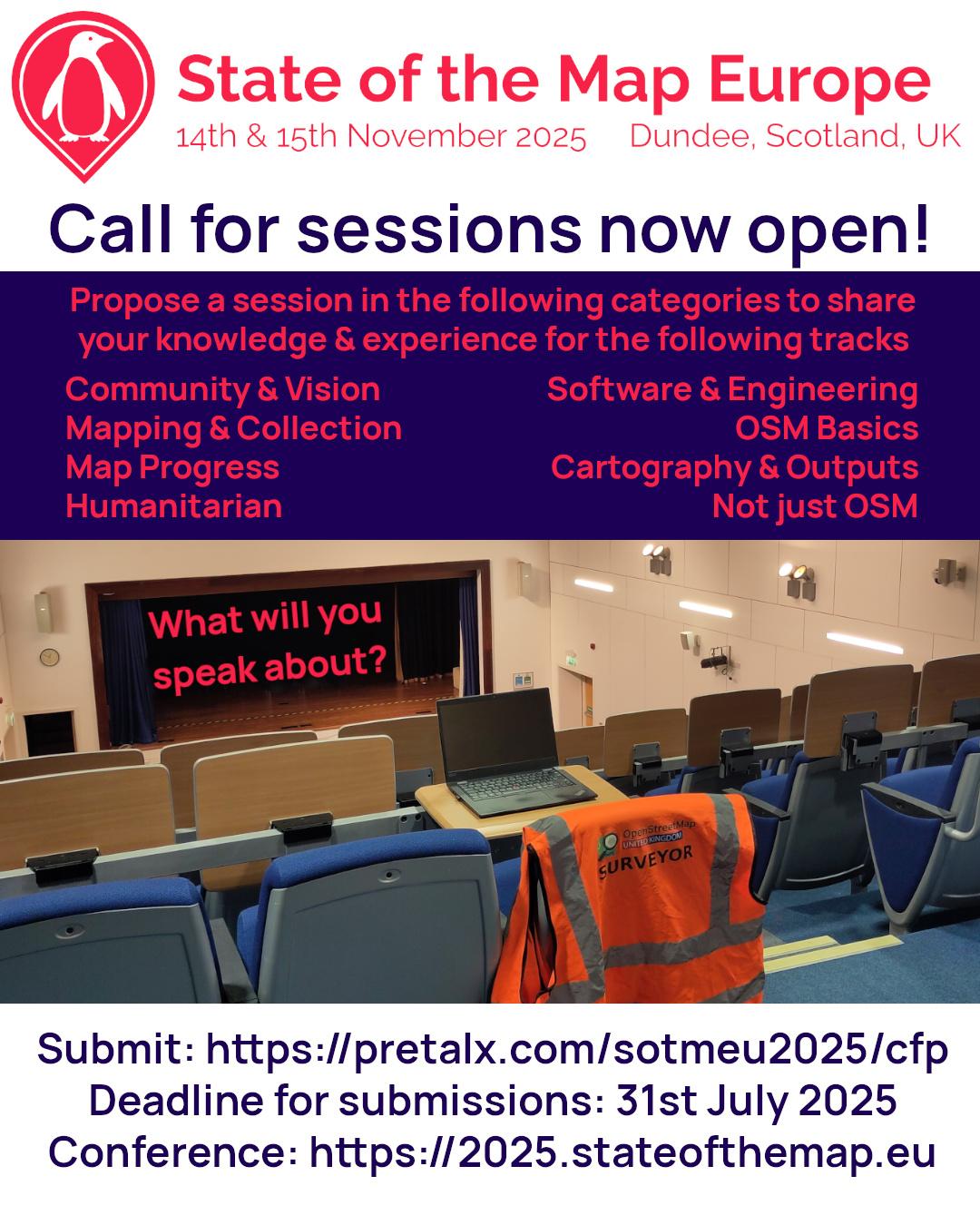
Our call for sessions is open! We're looking forward to your submissions at https://2025.stateofthemap.eu/index.html#schedule
Thank you #SOTMEU2024 Bronze sponsor @Mapbox, long-time OSM data consumer and community supporter through initiatives like ours and as an OpenStreetMap Foundation Gold Corporate Member.

We'd like to thank Overture Maps Foundation for helping us organise #SOTMEU2024 by becoming our Bronze Sponsor. Overture combines OSM data with external sources to provide license-compatible datasets for the community.

We're glad to announce that Hexagon supports the organisation of this year's #SOTMEU as a Bronze Sponsor. Hexagon provides a range of geospatial solutions including GNSS, surveying software, geospatial platform and more.

We would like to thank Microsoft for sponsoring this year's #SOTMEU. Microsoft has been supporting the community since 2010, when they first allowed Bing imagery to be used for OSM mapping, and is currently a Platinum member of the OpenStreetMap Foundation.
#SOTMEU2024 #StateoftheMapEurope #OSM #OpenStreetMap #Microsoft

One week left! On Thursday 18th July we'll start the OpenStreetMap Europe 2024 conference.
The time is short, but you may still get there, the tickets are available (concessions for active contributors at around 60 EUR), and the speakers are stellar! Reach us in case of any questions.
Schedule: https://cfp.openstreetmap.org.pl/state-of-the-map-europe-2024/schedule/
Tickets: https://tobilet.pl/state-of-the-map-europe-2024.html
Main website: https://stateofthemap.eu/
Our conference has been backed by Copernicus Data Space Ecosystem (CDSE): an initiative of the European Space Agency and the European Commission that is revolutionizing the processing and distribution of Copernicus Earth Observation (EO) data.
The project is being implemented by industrial consortium partners: T-Systems, CloudFerro, Sinergise, VITO, DLR, ACRI-ST, and RHEA.
#StateoftheMapEurope
#OSM
#OpenStreetMap #CDSE #Copernicus #EarthObservation #SatelliteData #CopernicusEU #EUspace #EOdata
, ACRI-ST, RHEA")
Get active!
This year, there will be plenty of chances to get your hands dirty at #SOTMEU!
Mateusz Konieczny will teach how to edit OSM Wiki, you can map Łódź with #StreetComplete, Andrew Hain will conduct a mobile mapping workshop, and if that's not enough, Michael Montani will introduce you to data validation in OSM, and everyone will have a chance to set up their own openrouteservice instance with Julian Psotta.
Links below!
Are you an active OSM Contributor?
We want to thank you!
If you would like to participate in the conference and in the last year you edited at least 42 days (https://hdyc.neis-one.org/statistics), send us a message @ osm.org/user/jendrusk, and in response you will receive a promotional code thanks to which you can buy a ticket for PLN 249!
The number of promotional tickets is limited - grab yours today!
Schedule and tickets: stateofthemap.eu

It's already this month: State of the Map Europe is coming up on 18-21 July!
In the upcoming days, we're going to present you with an overview of some of the presentations, and there's so many: over 40 events have been planned!
For a start, @pnorman, a maintainer of OSM Carto and member of Operations Working Group will describe the current state of work on the vector tiles to power OSM's main website with its needs.
See you there!
